District Profile
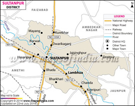
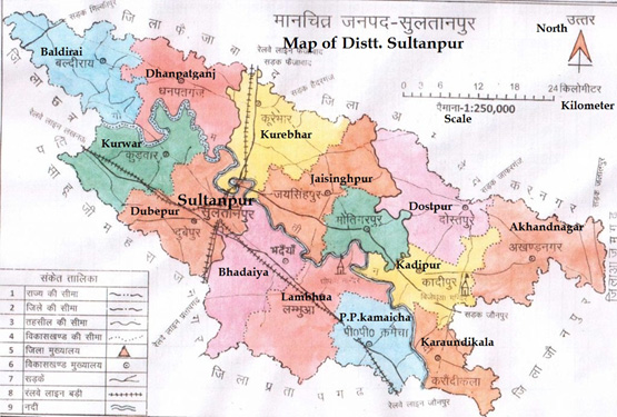
District Sultanpur belongs to Faizabad Division of Uttar Pradesh. Its distance from Faizabad is 60 Km and from Lucknow, the state capital, is 140 Km. It is well connected with road and railways from these districts. Amethi, Pratapgarh, Jaunpur and Ambedkarnagar districts are its neighbouring districts. The district is located on Faizabad and Ambedkar Nagar on the northern border of Sultanpur, Barabanki in the northwest, Jaunpur and Azamgarh in the east, Amethi in the west and district Pratapgarh in the south. River Gomti river flows in the district, in a natural way, the district is divided into two parts. District is situated on the banks of river Gomti which enters this district near north-west and enters Jaunpur, near the steep ray of south-east Dwarka. It lies at latitude 260 15’ north and longitude 820 05’ east. The total geographic area of the districts is about 2672.89 Kilometer2. The administrative district of Sultanpur district is five tahsils – Sadar, Bldirai, Jaysinghpur, Kadipur and Lumbuwa and 14 development blocks – Akhand Nagar, Dostpur, Karoudi Kala, Kadipur, Motigarpur, Jaisinghpur, Kurebhar, Pratappur Kamaicha, Lambhua, Bhadaiya, Dubepur, Dhanpatganj, Kurwar and Baldirai. Sultanpur comprises of 1727 villages, 5 tehsils and 17 thanas.
Details of Tehlish and Blocks of districts Sultanpur
| S. No. | Name of Tehsils | Name of Blocks |
|---|---|---|
| 1 | Sultanpur (Sadar) | Dubeypur Kurvar |
| 2 | Kadipur | Kadipur Dostpur Akhand Nagar Karondi Kala |
| 3 | Lambhua | Lambhua PP Kamaicha Bhadaiya |
| 4 | Jaisinghpur | Jaisinghpur Kurebhar Motigarpur |
| 5 | Baldirai | Baldirai Dhanpatganj |
Area : 2672.89 Sq. KM
No. of Municipalities : 1
No. of Blocks : 14
No. of Revenue Disivions : 5
No. of Gram Panchayats : 986
No. of Nagar Panchayats : 3
No. of Villages : 1727
No. of Tehsils : 5
Sex ratio : 983
Male : 12,26,650
Female : 12,04,840
Child sex ratio : 922
Topography
The surface is generally level, being broken only by ravines in the neighborhood of the rivers. The central portion is highly cultivated; while in the south are widespread arid plains and swampy marshes. Minor streams are the Kandu, Pili, Tengha and Nandhia. Apart from this, the Garbhiya Nala, Mazui Nala, Jamurya Nala, and Bhat Village Karkharva, Sobha Mahona etc. are lakes. The land of Sultanpur district is generally plane except some regions around the Gomti River which drains almost the whole district. However, the southern part of Sultanpur drains towards Sai River flowing through the Pratapgarh district.
Climate
The climate of this district is characterized by a hot summer and a pleasant cold season. The climate is semi-arid with very hot summer and equally cold winter season. During the summer months i.e. May-June, the maximum temperature goes beyond 44 degree Celsius and in winter months of December & January, it is around 3-4 degree Celsius. Winds are generally light to moderate with some strengthening during later part of the summer and monsoon season. Winds are mostly from the east or south-east during the period from May to September. The average annual rain fall is about 900 to 1000 mm and confined mainly during July to September. The rainfall in general increases from the south-west towards the north-east and about 80-85 per cent of the annual rainfall is received during the south-west monsoon months June to September, July being the rainiest month. Hail and Dust Storms are observed only during March to June.
Soil
Alluvial soils generally cover the major portion of the district. They have developed an alluvium deposited by the Gomti and its tributaries. The soils are neutral to moderately alkaline and calcareous and have sometimes, well developed clay accumulation in the sub-soils. The large areas of barren waste are striking characteristics of the district. Tahsil Sultanpur has the greatest area of such land. Most of this area is of a very unproductive nature and consists of wide usar plains, which are specially noticeable in the south and the east of district. Nothing grows on such land, not even grass. Most of the land affected by soil erosion in the district lies in the water sheds of the rivers Gomti, Mangar, Majhai and Sai.
Land Use Pattern
The mainstay of the population is still agriculture and more than 90 percent of families have excess number of persons engaging themselves in agricultural related activities. Out of the total geographical area, about 67% is devoted to Agriculture. The culturable and non-culturable waste land contributes 14.85 % and 18.21 % respectively. The main occupation of the people is agriculture, the crop pattern was all alike on the usual pattern of harvesting two crops rabi and kharif. But zaid crop are also found in this district.
Agro-Ecological Situations
As per the survey of the district, it has been observed that agro-ecological situations are directly correlated with physiographic situations, land quality and availability of irrigation facilities of the area. Broadly, the farming situations have been divided into four i.e. productive plain, sodic, ravenous and waterlogged conditions. The first three conditions, are further divided into two i.e. irrigated and rain fed. The waterlogged areas are temporarily or permanently submerged in nature. Bore well is the major source of irrigation (48.5%) followed by canal (38.65%) and public tube wells (9.17%).
| AES | Particulars | Farming System |
|---|---|---|
| AES-1 | Productive plain land under Canal and tube-well irrigation | - |
| a | Main branch + Tube-well | Specialized farming i.e. rice, wheat / potato. Urd / moong, sugarcane supported by buffaloes/cows. |
| b | Main branch + Tube-well | Rice, Arhar+urd+til, vegetables, wheat gram + mustard, pea horticultural crops with cows / buffaloes. |
| AES-2 | Productive plain land under tube-well irrigation | Mixed and diversified farming i.e. rice, arhar + jowar+til, urd / moong, fodder crops, vegetables and horticultural crops, wheat gram, pea mustard, toria with few cows and buffaloes. |
| AES-3 | Sodic land under canal + tube-well irrigation | Rice, wheat/ mustard, vegetables and other horticultural crops, arhar + jowar, and some other crops are growing in pockets with few local cows / buffaloes and goats. |
| AES-4 | Waterlogged under canal and Tube - well irrigation | Rice, wheat, mustard, lentil, gram, pea, vegetables in pockets, fodder crops and other horticultural trees with few cows and buffaloes. |
| AES-5 | Eroded cultivable land under Tube - well irrigation | Rice, arhar + jowar + til/ urd/ moong, maize, chari as fodder. Wheat / barley, gram + mustard, peas, lentil, groundnut, vegetables and other horticultural trees with few cows, buffaloes, goats and sheep. |
| AES-6 | Rainfed-eroded cultivable land and ravines | Arhar + jowar + til/urd, maize. chari as fodder crops, millets, barley / wheat. gram, pea, lentil mixed with mustard. kharif vegetables, fruits and other forest trees with cows / buffaloes and goats. |
Area under different AES
| S.No. | Types of Land | Irrigated | Rainfed | Total |
|---|---|---|---|---|
| 1 | Productive Plain land | Canal + Tubewell : 24% (AES-1) Tubewell : 17% (AES-2) Total - 41% |
4% | 45% |
| 2 | Sodic Land | Canal + Tubewell : 10% (AES-3) Tubewell : 5% Total - 15% |
2% | 17% |
| 3 | Eroded and Ravine Land | Canal + Tubewell : (AES-6) | Tubewell : 9% (AES-5) | Total - 9% 21% 30% |
| 4 | Waterlogged Area | Canal + Tubewell : 8% (AES-4) Total - 8% |
- | 8% |
| Total% | Canal + Tubewell : 42% Tubewell : 31% Total - 73% |
27% | 100% |
Crop and cropping pattern
The agriculture of the district does not differ much from that of neighbouring districts. The main harvests of the district are known by the usual names kharif (autumn) and the rabi (spring) crops. The kharif crops are sown in the beginning of hot weather and reaped after cessation of the rains; the rabi crops are sown in October–November and reaped in March-April. The zaid or intermediate harvest which reaped before the summer rains is not of great importance in the district. Among the kharif crops paddy is the most important in point of the area under it. Other kharif crops are arhar, maize, urd and mung. The rabi crops consists of wheat, barley, gram and pea grown.
Rice is the most important crop of kharif and accounts for 34.78% of the total cropped area. The degree of dominance is comparatively less in the north-western part than the south-western part of the district. The next most important cereal crop is wheat which occupies nearly 25% area of the total cropped area and well distributed all over the district. Other crops like barley and millets occupied 4% and 5% of the gross cropped area respectively. Pluses cover only 15% of the total gross cropped area. Gram is the most important crop and accounts for 18% followed by pigeon pea (3.19%), field pea and lentil. Mustard is the main oil crop grown in rabi, mixed with gram, pea, wheat and lentil. Sugarcane is cultivated as cash crop and occupies only 1.82% of the total gross cropped area. Cultivation of horticulture crops, specially the vegetables are mainly restricted to traditional families except potato, onion and sweet potato which are widely grown by majority of the farmers in the district. Potato occupies only 1.23% of the total gross cropped area followed by onion, sweet potato and other vegetables. Among the fruit crops Mango occupies a maximum area (15,517 ha) followed by guava (81 ha), aonla and jackfruit.
The cultivators of the district had the services of seed godowns, fertilizer depots, rural godowns, insecticide depots, seed farm, cold storages and agriculture service centre. For storage of crops there were many warehousing godowns, among which some were managed by Food Corporation of India and State Warehousing and by State government.
Live stocks and fisheries
Animal husbandry is yet another sector which supports economy after agriculture. The domestic animal of local variety is found in the district. The cattle bovines, buffaloes, sheep, goats (he and she), pigs, poultry birds are the other animals. The condition of live- stock is worst in problem areas due to shortage of feed, fodder and occurrence of diseases. Nowadays, poultry farming has become important in the district with increasing demand of poultry products. Animal Husbandry departments make arrangement for supply of fowls to those interested in poultry farming.
The district has an immense potential for fresh water fisheries through large system of rivers and inland water bodies. Gomati River is an important source of fishes which covers a length of 207 km in the district. There are 5,636 ponds with water spread area of about 4,500 ha. The most prized species are the Anwari or Mullet and Rohu which are found in abundance in the Gomti. Majority of the fisherman population is concentrated in the village along the bank of Gomati River. Catching and selling of fishes is the main source of their livelihood. Housewives are mainly involved in rope making from Saccharum species which grows widely in the ravine areas.
The Need
As a whole, district is characterized by typical socio-economic and agro ecological situation. The majority of the farming community falls under marginal and small categories with fragmented holding scattered at different locations and poor resources. The soil condition of the district is inherently productive but a good proportion of land is beset with productive hazards as stated earlier.
Thus, there is a constant need for vertical as well as horizontal improvement of agriculture production in an integrated manner to uplift the socio-economic condition of the farming community. The majority of farming community suffers with a number of problems such as low level of knowledge, poor credit facility, input support, poor condition of soil, fragmented holdings and unemployment. Keeping in view the above, the following thrust area have been prioritize and taken into consideration for improvement of agriculture development in the district.
Priority thrust areas
| S. No. | Thrust area |
|---|---|
| 1 | Management of rice – wheat cropping pattern |
| 2 | Promotion of organic farming |
| 3 | Diversification of existing cropping system |
| 4 | Promotion of resources conservation technologies |
| 5 | Promotion of seed production (seed village concept among farmers) |
| 6 | Enhancement in milk yield of cattle and buffalo |
| 7 | Promotion of fruit crops ( Aonla , Guava, Mango, Banana, Agro- forestry) |
| 8 | Entrepreneurship development in dairy, poultry, goatery, bee keeping, floriculture, vegetable and mushroom production |
| 9 | Promotion of agro processing technologies for value addition |
| 10 | Rain water harvesting and soil health management |
| 11 | Post harvest management of agricultural products |
| 12 | Disaster management / unseasonal rainfall/hail storm/cold waves etc. |
| 13 | Crop residue management |